ST. GEORGE — A recent storm came with a thundering roar across Southern Utah on Thursday evening. But not before a lightning show lit up the night.
The start of what is expected to be a weekend of stormy weather dumped 1 to 2 inches of rain in the St. George area between 7 p.m., Thursday to 6 a.m., Friday with lightning flashing like strobe lights in repetition in the sky.
A couple basements suffered flooding, fallen trees were scattered from high winds and some roads flooded throughout the city.
Further north, the Cedar City area had less rain — about 0.08 inches overnight — but still had high winds with gusts up to 60 mph.
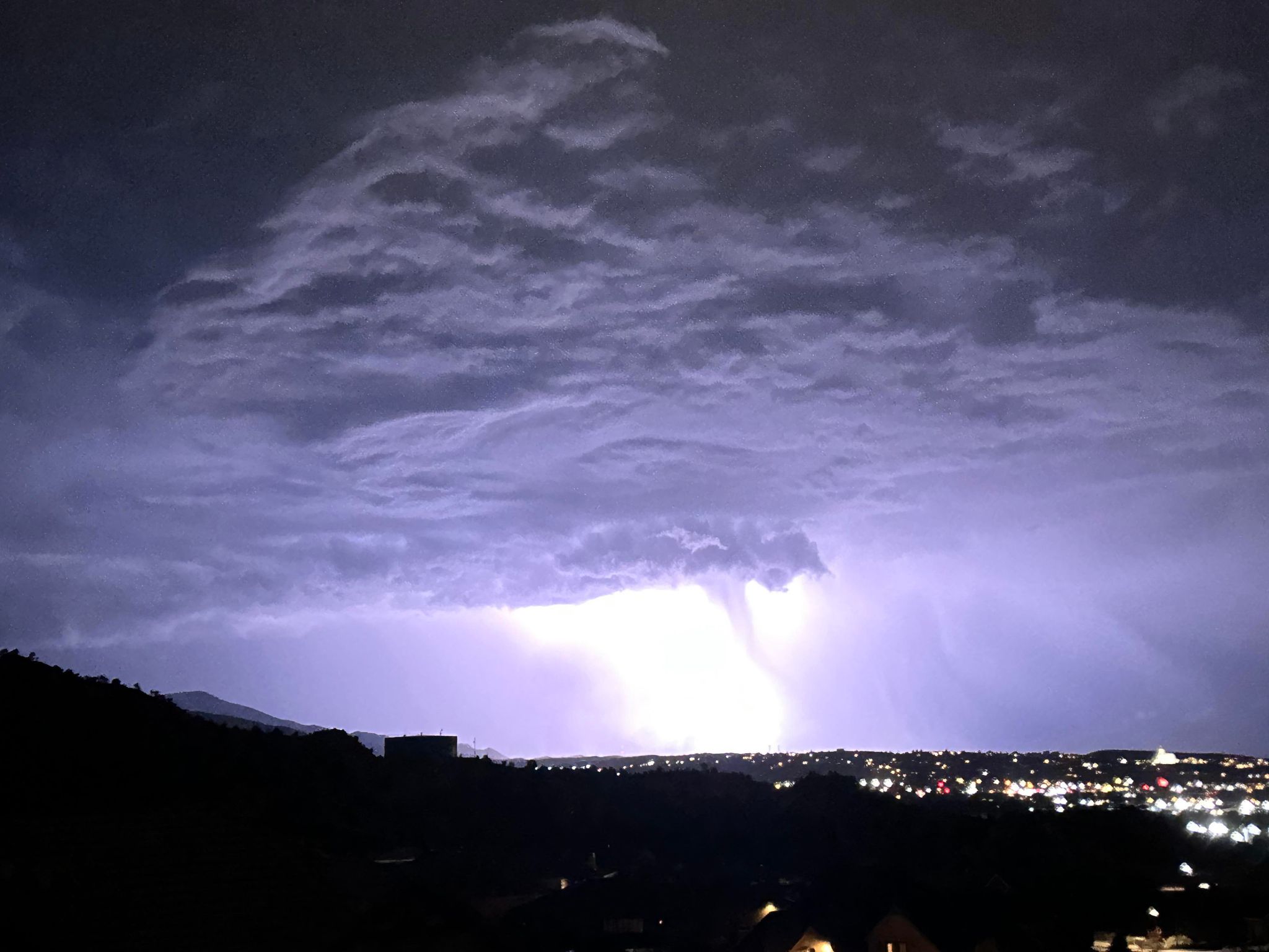
Cedar City resident Tessa Douglas caught what looked like a funnel cloud during the night, but the National Weather Service said there was no tornadic activity in the area when St. George News inquired.
The forecasters did say to expect an encore performance in the sky Friday night into Saturday morning.
Meteorologist Haden Mahan with the National Weather Service’s Salt Lake City office told St. George News that residents who thought there was something unusual with this lightning storm were right, especially as far as the frequency of the lightning.
“A lot of the aspects of this storm were pretty unusual,” Mahan said. “St. George was pretty much the bullseye and there were two inches of rain by Ivins.”
Mahan noted, as he had leading up to the arrival of a strom front expected to stick throughout the weekend, that this storm is a combination of the usual summer monsoonal moisture coming from the south with a fall-like storm coming in from the west.
This is creating a lifting of warm air into the colder air above and the combination produces significant lightning. That also means the rain being widespread and lasting longer than typical summer monsoons.
“We have a much better lifting mechanism,” Mahan said. “These can pop up wherever and sustained wherever.”

Along with the lightning and rain came extremely high winds throughout Southern Utah, with gusts up to 61 mph reported by the National Weather Service in Cedar City, Leeds and Kanaraville.
One Cedar City resident captured what looked like a funnel cloud — a tornado that hasn’t touched the ground.
“I was literally just snapping my phone camera over and over trying to catch lightning, and that appeared in one of the photos,” said Tessa Douglas, whose vantage point was above Cedar Ridge Golf Course in northeast Cedar City looking toward New Harmony. “It was pretty exciting and unnerving. That was definitely a crazy storm.”
Alas, Mahan said they have examined both the picture and radar data from the time near the Cedar City area and it was “very likely” not a funnel cloud. Nor was there any tornadic activity in the area.
“We went back on the radar and we were trying to see if there is maybe some sort of signal we couldn’t really see one,” Mahan said. “I am thinking that it was probably something with the flash of the lightning and the photo making it sort of appear what looked more like a rain shaft that was just at the right angle with the lightning and the photo to make it appear like some sort of a funnel. But the high winds were too widespread to be a tornado.”
With the winds in Cedar City just 10 mph less than the minimum 71 mph to be classified an F1 tornado, there were still residents who felt the impact.
David Walker, who lives in the Spring Creek subdivision in southwest Cedar City, said the roof of his patio was ripped off.
“We have lived in our home for 25-plus years and had some big storms, but nothing like this thing that came through,” Walker said. “ It tore a couple of large branches off the poplar tree in our front driveway. All this has caused us to believe we suffered more than a strong thunderstorm. We believe a mini-tornado hit us and ripped off our patio roof.”
Back in St. George, most the rain fell between 8 p.m. and midnight Thursday night — about an inch — with another quarter of an inch coming in the 6 a.m. hour Friday morning, according to the weather service.
It proved to be a busy night for police officers and firefighters in Washington County between flooding and fallen vegetation.
“We had some trees fall, basements flooded, power lines down, mud in the streets,” St. George Police officer Tiffany Mitchell told St. George News.

St. George Fire Chief Robert Stoker said the flooded basement was at student housing on S. 1000 East near Utah Tech University.
“The majority of the flooding came off their own property,” Stoker told St. George News. “We had several areas where trees were blown over, mainly downtown. We had high-water runoff throughout the city but the drainage system handled it even though it was overwhelmed.”
One tree fell on the 150 block of S. Main Street blocking the road for a time Thursday night and damaging a fence. Stoker said a tree near the center of town leaned up against a house, contrary to social media rumors, the tree did not damage the house.
Ultimately, if there’s a tree down in a public area or anyone is in danger during a storm, the fire department will help.
“As a fire department, we’ll look at those. But if there is no immediate danger, it is up to the homeowner to take care of that,” Stoker said. “If it’s in the streets, our crew will work to remove it.”
Stoker said lightning hit a power tower near the university, causing a brief power outage in the area. In Santa Clara, an inch of water flooded a basement in one home.
“We had a long night,” Santa Clara-Ivins Fire & Rescue Battalion Chief Con Fulde told St. George News . “Just little things. Mostly surface water and a lot of washouts on the road.”
Over the border in Mesquite, Nevada, a power line that went down at the corner of Haven Lane and Arrowhead Lane from the wind caused a widespread power outage, the National Weather Service said in its tornado and high-wind report.

And local first responders and residents may be in for another long night. Mahan is predicting that Mother Nature will be providing an encore Friday night.
“We are expecting some more storms to develop later this afternoon near the Vegas area and spread into Southwestern Utah. Probably around 5 to 6 p.m., Mahan said. “It could be a, a similar repeat of last night in terms of lots of lightning and lots of heavy rain.”
Update Sept. 1, 1:00 p.m. Many more details from the ground, forecast ahead and video added.
Photo Gallery
Lightning from storm over St. George, Utah, Aug. 31, 2023 | Photo courtesy Andy Hintze, St. George News Lightning from storm over St. George, Utah, Aug. 31, 2023 | Photo courtesy Andy Hintze, St. George News Lightning continued in the morning from storm over St. George, Utah, Sept.1, 2023 | Photo courtesy Andy Hintze, St. George News National Weather Service said light from lightning made a shaft of rain look like a funnel cloud over Cedar City, Utah, Aug. 31, 2023 | Photo courtesy Tessa Douglas, St. George News Lightning over Cedar City, Utah, Aug. 31, 2023 | Photo courtesy Tessa Douglas, St. George News Lightning over Cedar City, Utah, Aug. 31, 2023 | Photo courtesy Tessa Douglas, St. George News Lightning over Cedar City, Utah, Aug. 31, 2023 | Photo courtesy Tessa Douglas, St. George News Lightning over Cedar City, Utah, Aug. 31, 2023 | Photo courtesy Tessa Douglas, St. George News Lightning continued in the morning from storm over St George, Utah, Sept.1, 2023 | Photo courtesy Bert Berger, St. George News Lightning over Snow Canyon State Park, Aug. 31, 2023 | Photo courtesy Bert Berger, St. George News Lightning from storm over St. George, Utah, Aug. 31, 2023 | Photo courtesy Kimmy Bassett, St. George News Tree fallen from high-wind storm on Main Street, St. George, Utah, Aug. 31, 2023 | Photo by Joseph Witham, St. George News Tree fallen from high-wind storm on Main Street, St. George, Utah, Aug. 31, 2023 | Photo by Joseph Witham, St. George News Crews clean up tree fallen from high-wind storm on Main Street, St. George, Utah, Sept. 1, 2023 | Photo by Joseph Witham, St. George News Crews clean up tree fallen from high-wind storm on Main Street, St. George, Utah, Sept. 1, 2023 | Photo by Joseph Witham, St. George News Rainwater pools in Washington City, Utah, Sept. 1, 2023 | Photo by Vin Cappiello, St. George News
Rainwater pools in Washington City, Utah, Sept. 1, 2023 | Photo by Vin Cappiello, St. George News
Rainwater pools in Washington City, Utah, Sept. 1, 2023 | Photo by Vin Cappiello, St. George News
Lightning from storm over St. George, Utah, Aug. 31, 2023 | Photo courtesy Andy Hintze, St. George News Satellite image of Western U.S. and storm over Southern Utah at around 11 p.m. MDT, Aug. 31, 2023| Photo courtesy National Weather Service, St. George News
")


Copyright St. George News, SaintGeorgeUtah.com LLC, 2023, all rights reserved.