ST. GEORGE — As the St. George area’s namesake marathon returns this Saturday for the 46th year, so do the thousands of runners, volunteers and road closures that accompany it.

The race, which starts in Central on state Route 18 and runs south into St. George, will shut down access to much of SR-18 and parts of downtown St. George for up to half a day.
Closures will begin Thursday starting at 7 a.m. as 300 East between 300 East and 400 East by Vernon Worthen Park are blocked off for the set up of the marathon’s finish line.
Additional closures in the area of the park will continue Friday, starting in the morning. Evening closures will also occur in conjunction with the Fun Run Walk n’Roll.
On race day, the St. George Police Department will have signs set up at various road closure locations. The signs will have a QR code that motorists can scan with their smartphones.
Once scanned, the smartphone will open a map showing detours and alternate routes around the marathon course.
Up to 5,000 runners are expected to participate in this year’s St. George Marathon.
“Expect heavy delays as the majority of the course is closed throughout the duration of the race on Saturday,” the city of St. George stated in a letter recently sent to area residents. “Please obey all traffic and parking laws, officers, and volunteers as they direct traffic. In addition to vehicle traffic, cyclists are restricted to the trail along the route.”
Friday road closures
Closures will take place on 300 South from 200 East and 300 East, and 300 East from 200 South to 400 South starting at 7 a.m.
400 East from 100 South to 300 South will close at 5 p.m.
Intermittent closures will occur on 100 South from 400 East to 100 East and 100 East from 100 South to 300 South and 300 South from 100 East to 400 East for the Fun Run Walk n’Roll event.
Shoulder parking on Diagonal Street from Bluff street to 300 West will begin at noon.
Saturday road closures and detours
The Mayor’s Walk

Prior to thousands of marathoners running into downtown St. George, the city will host the Mayor’s Walk, which starts at 7 a.m. at the Washington County School District parking lot at the corner of Tabernacle Street and 200 West.
From there, participants will head to 200 East, then south to 300 West and then east again to the finish line near 400 East/Flood Street.
The parking lot can be accessed off Bluff Street at 100 South or up 200 West south of Tabernacle Street by the Washington County School District administration building.
The St. George Marathon
Marathoners will begin to be bused to the starting line between 3:45-5:20 a.m. on 400 East by Vernon Worthen Park. The race starts at 7 a.m.

SR-18
SR-18 between Central and the Ledges will be closed for the marathon.
Two-way travel between the Ledges development and the Snow Canyon Parkway/Red Hills Parkway intersection will be available in the west lanes of SR-18.
Southbound traffic from SR-18 will be allowed to continue down Bluff Street, while northbound traffic on Bluff Street will be diverted west onto Sunset Boulevard, north up 100 West, and then east on Snow Canyon Parkway till it reconnects with SR-18.
Diagonal Street
Access to Diagonal Street will be closed between Bluff Street and 300 West. Limited neighborhood access between 600 West and 300 West will be available.
300 West
Access to 300 West will be closed between Diagonal Street and Tabernacle Street. This will cut the east-west connection for the streets that run through this segment of 300 West, including St. George Boulevard.
Tabernacle Street to Main Street to 300 South
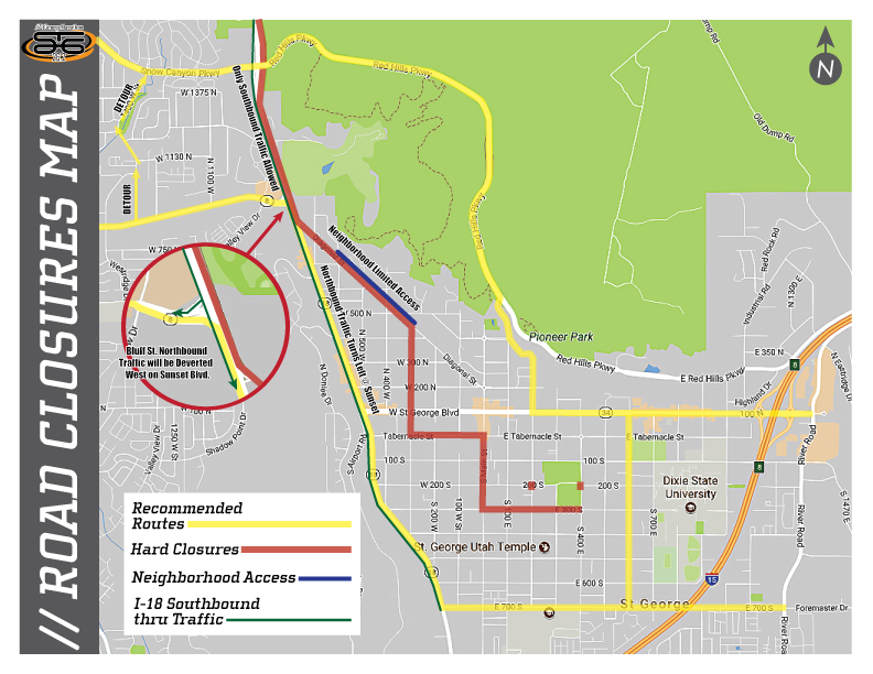
Tabernacle Street will be closed between 300 West and Main Street. Main Street between Tabernacle Street and 300 South also will be closed, with 300 West between Main Street and 400 East/Flood Street by the Vernon Worthen Park also being closed off for the race.
Motorists also can expect general access to Vernon Worth Park, where the finish line is located, to be closed.
East-west detours
People needing to travel either east or west through St. George between Bluff Street and Interstate 15 can do so by diverting to 700 South or Red Hills Parkway. These streets are connected on the west side of I-15 at 700 East and on the east side of the highway by River Road.
Motorists can access Red Hills Parkway off St. George Boulevard by turning north onto 200 East and following the road until it connects with Red Hills Parkway.

Copyright St. George News, SaintGeorgeUtah.com LLC, 2022, all rights reserved.