ST. GEORGE — It’s no secret that Utah is getting hotter and drier by the year, with prolonged heat waves and declining snowpack intensifying an already dangerous wildfire cycle.
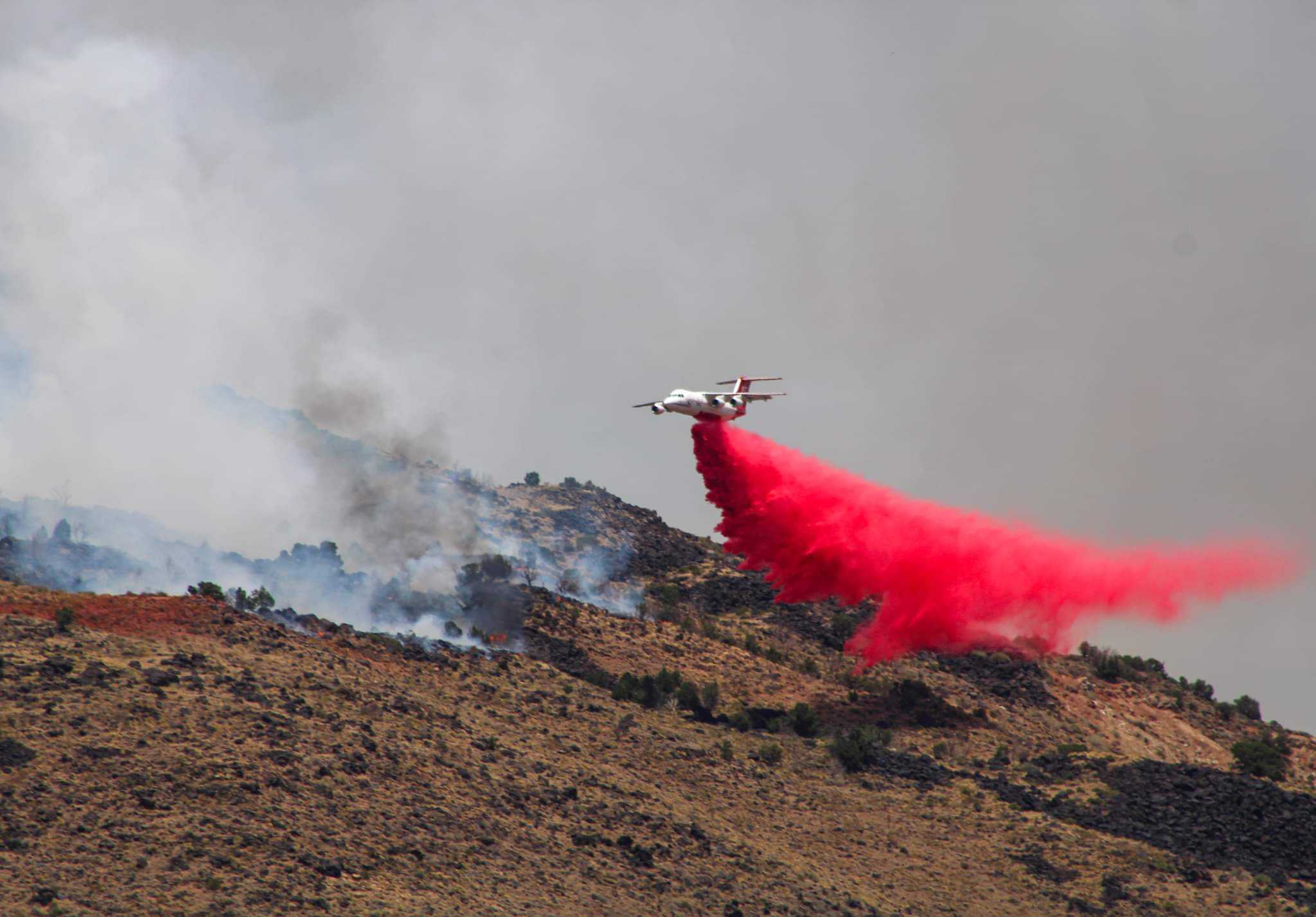
The rapid spread of last week’s 370-acre blaze near Virgin illustrates the destructive potential of recent wildfires, as did Utah’s largest wildfire in 2021: a 14,000-acre blaze that spread almost to the doorstep of Enterprise homes.
Now, residents throughout Utah and across the country can see the relative risk of wildfire for individual homes, neighborhoods and even entire counties with the release of a new online tool developed by the First Street Foundation.
According to the foundation’s predictive model, Utah leads the nation with the highest fire risk when measured as a share of all properties – and Southern Utah leads the state. Over 93% of properties in Washington County have at least a 6% chance of experiencing a wildfire in the next 30 years.
The fire outlook for local communities is so extreme that the New York Times chose Dammeron Valley as a model for the intersection of development, drought and fire risk. All of the homes in the growing community face at least a 26% chance of damage from wildfire at some point in the next 30 years.
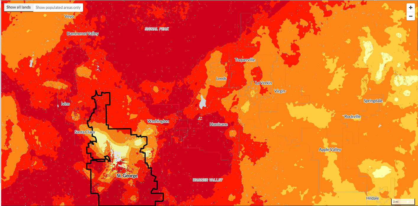
All of St. George’s residences are similarly threatened by wildfire in the next 30 years, though to a lesser extent. About 95,000 properties in St. George have at least a 0.2% annual chance of experiencing a wildfire, which corresponds to a 6% chance in the next 30 years.
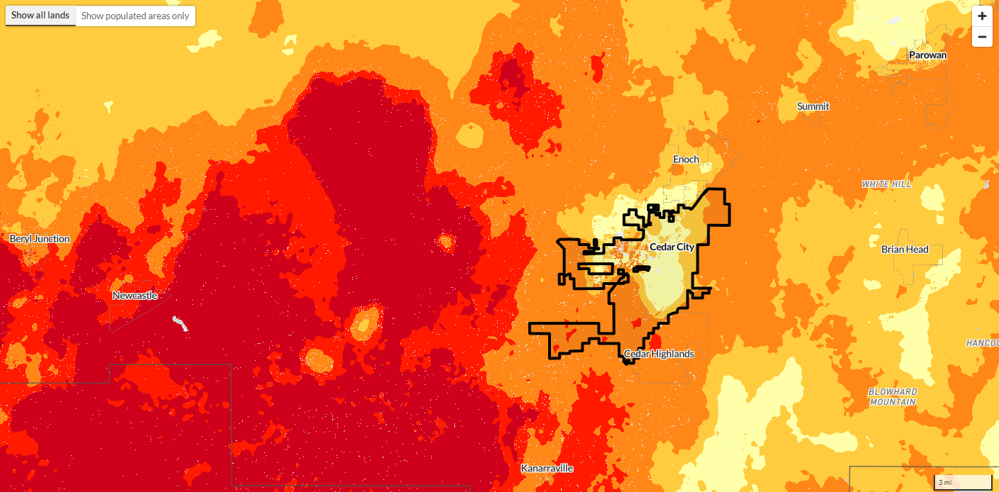
Compare that to Cedar City, which faces a severe risk by national standards, but one that is reduced compared to its neighbors further south. According to the risk assessment, there are 14,334 properties in Cedar City that have some wildfire risk over the next 30 years.
To craft the wildfire model, the foundation worked with the Pyregence Consortium – a fire science cooperative – and gathered publicly available data from state and federal agencies including the U.S. Forest Service and the National Oceanic and Atmospheric Administration.
Factors such as hourly surface wind, air temperature, relative humidity, precipitation and historic fire behavior were used to estimate this year’s fire risk, while climate models using projections of the same factors at different levels were generated and compiled to estimate future risk. The estimates go all the way up until 2052 to cover the 30-year period of a typical mortgage.
Prior to the First Street Foundation’s model, the only similar public resource was the Wildfire Risk to Communities tool maintained by the U.S. Forest Service. True to its name, the older tool could give estimates of wildfire risk to entire communities but could not offer details on a property-by-property basis like the foundation model.
According to the U.S. Forest Service’s model, St. George’s populated areas face a greater risk from wildfire than 87% of communities in Utah, while Cedar City occupies the 57th percentile for wildfire risk in Utah. Compared to the national average, St. George and Cedar City are in the 96th and 87th percentiles, respectively.
Wildfire models help land managers and now private citizens to make informed decisions for land management and resource allocation. The cost of fighting wildfires has increased year after year, with the cost of wildfire damage in 2020 and 2021 ($28.7 billion) being more than the combined cost of damage from 1990-2007, according to data from NOAA.

There were fewer acres burned in 2021 compared to 2020, but the National Interagency Fire Center reported that federal firefighting costs continued to rise – climbing above $600 per acre.
Using the First Street Foundation model, in addition to consulting local fire resources, current and prospective residents can evaluate the projected risks of fire and make informed decisions before buying a new home or developing commercial property.
With the current climate outlook in Southern Utah, it’s not so much if a wildfire will strike but where and when – and whose property will be affected.
Copyright St. George News, SaintGeorgeUtah.com LLC, 2022, all rights reserved.