ST. GEORGE — Change is coming to the nearly 7,000 acres of land west of St. George that has long been a beloved site for outdoor recreation.
The changes will not be sudden, but a gradual and possibly multiyear-long process as efforts are made to educate the public that an area once used for hiking, mountain biking or off-highway vehicle riding is now a part of the Red Cliffs Desert Reserve.
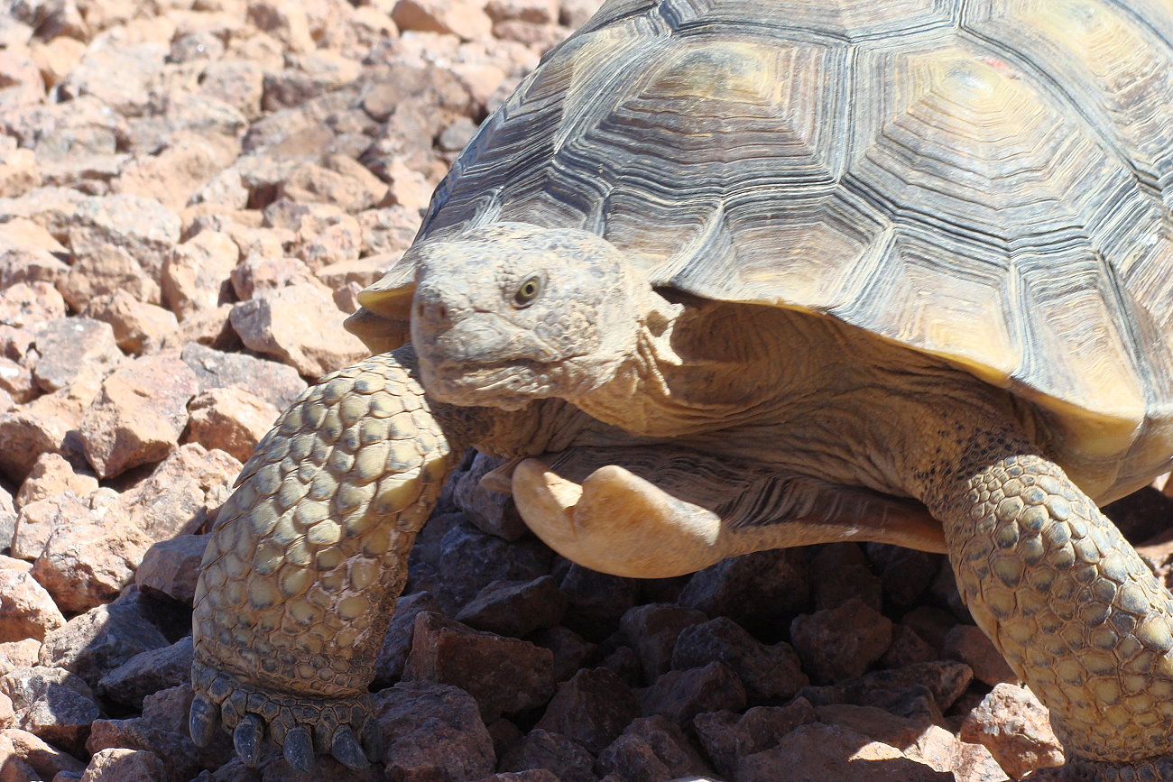
More tortoise habitat in exchange for a roadway
Composed of a mix of state school trust lands and public lands managed by the Bureau of Land Management, this area, known as Zone 6, is now officially a part of the Red Cliffs Desert Reserve following the renewal of the Washington County Habitat Conservation Plan in January.
Located west of Bloomington and south of Santa Clara, this land was made a part of federally-protected Mojave desert tortoise habitat in exchange for land within the reserve that will be disturbed by the creation of the Northern Corridor. The roadway will cut through four miles of the desert reserve and the overlapping Red Cliffs National Conservation Area.
Previous surveys done by county and state wildlife officials in the area have found a sizable desert tortoise population there despite ongoing recreational use, and it is due to this notable presence of the threatened reptiles that Washington County officials proposed making it a part of the Red Cliffs Desert Reserve as an offset for the Northern Corridor.
Changes and outreach will take time
In the wake of that change, desert reserve staff will be focused on public outreach and education in order to let people know the area is now a part of protected tortoise habitat, and that some outdoor activities they previously enjoyed may end up being modified or prohibited.

“Right now the focus is on education and outreach,” Lura Snow, outreach coordinator for the Red Cliffs Desert Reserve, said. “We’ll be letting people know that it’s a part of the reserve and that there are certain areas out there that are being preserved as tortoise habitat.”
Reserve staff also hope to dispel any rumors to ensure people have all the facts they need about the new addition to the desert reserve; however, that will take time.
“It’s going to be an ongoing, multiyear effort,” Snow said, adding that changes coming to Zone 6 likely won’t happen for a while yet. “Nothing is happening in the immediate sense beyond getting the word out …. There are many things that need to happen and we anticipate process to be ongoing for the next five years.”
Among the changes taking place, which also have some outdoor enthusiasts and public lands use advocates worried, is the reduction and restriction of off-highway vehicle use where it was previously unhindered.
Focus toward non-motorized recreation
“There are on going to be changes to the road structure, but we haven’t started that process yet,” Snow said. “We’re going to be moving our focus toward non-motorized recreation, so we are going to be emphasizing more mountain biking, hiking and rock climbing as far as what responsible recreation in the area looks like.”

According to the Washington County Habitat Conservation Plan, the existing trail system within Zone 6 – which consists of official and unofficial, un-designated trails – runs an estimated 150 miles. This includes primary and secondary unpaved roads, single and two track trails, and other trails marked as “unknown/other” that make up just under half of the overall system.
This will be reduced to 42 miles of designated trails within Zone 6 with an added emphasis of not going off trail or creating new, unofficial paths.
Concern over loss of trail access
A group that both supports the land exchange that helped Washington County secure the long-sought, right-of-way for the North Corridor but also worries about the loss of use and access to public lands is the Utah Public Lands Alliance.
“Over 100 miles of trails will be closed to all motorized vehicle traffic,” a statement on the nonprofit’s website states.
The group further states that the change left out stakeholders who should have had more say in how the trail issue was addressed.
“Hiding behind the cover of Covid, this action was taken without knowledge, comment, or involvement of any offroad users,” the website states.

Kevin Keller, chairman and CEO of the nonprofit, told St. George News they weren’t aware of any possible trail closures until after the new plan for the desert reserve was approved. While he said that that was partially an oversight on their part, he nonetheless wished off-road vehicle users had the opportunity to offer more input.
“What we worry about is finding closed signs on trails we’ve traditionally used,” Keller said. “We want to be proactive in that we understand what everyone’s plans are and make sure our interest are brought to the table.”
Many of the trails that have been used by off-vehicle riders, at least on the 3,230 acres within Zone 6 owned by Utah’s School and Institutional Trust Lands Administration – more commonly known as SITLA – are not officially recognized, said Kyle Pasley, SITLA’s assistant director of planning and development.
“What is designated is the old Apex Mine road, which is a county road, which is the main one that leaves off Navajo Drive (in Bloomington),” Pasley said. “That will stay open. Outside of that, there are no established trails with the agency.”

SITLA has closed off access to off-highway vehicles on occasion, Pasley added. This typically happens if there is a perceived danger to OHV riders or damage may be caused to a sensitive area by OHV use. Overall, however, STILA has been rather lenient about the situation, However, the organization also asks that individuals recreating on SITLA land not go off-trail.
Unlike the BLM, which manages over 3,470 acres with Zone 6, SITLA-held lands are not public lands, Pasley said, nor recognized as such under the law.
Remaining land inside Zone 6 is owned by private as municipal land owners, as well as the Utah Department of Transportation.
St. George News also contacted the BLM concerning the trails and recreational use within Zone 6, and received the following statement from BLM public affairs specialist Christian Venhuizen:
The St. George Field Office Resource Management Plan was amended to include several new land use restrictions within the Reserve Zone 6 to manage the area consistent with public lands in the existing five zones of the Reserve. This includes restrictions on activities that can be threats to desert tortoise and their habitat, including minerals development, rights of ways, certain recreation uses, and livestock grazing.
Although the Approved Amendments to the SGFO RMP limit the overall mileage of roads and trails on BLM-administered lands in Reserve Zone 6, they do not specifically create, close, or alter any trails at this time.
On BLM-administered, Utah School and Institutional Trust Lands Administration, and private lands in the Reserve Zone 6 area, there are currently 49.6 miles of routes designated for motorized use and 30.4 miles designated for non-motorized use. There are also 42.4 miles of user-created trails, which are unofficial routes. Washington County included an action to reduce, over time, the total miles of routes in the Reserve Zone 6 to 65 miles. This action will occur through future planning efforts that will include public involvement opportunities.
Another facet of outdoor recreation that will be discontinued within the boundaries of Zone 6 is target shooting. A part of the desert reserve’s outreach program will be letting people know about the Washington County Shooting Sports Park as a more viable and legal alternative.
Once more, Snow said letting people know about the changes coming to Zone 6 and how recreational use in the area will be modified, will take time, just as overall change to the zone itself will.
“It’s currently a work in progress,” she said. “It’s not going to be a fast, immediate and sweeping process. We’re going to be working with as many different recreational communities as possible to implement responsible recreation and to help identify alternatives for people.”
Copyright St. George News, SaintGeorgeUtah.com LLC, 2021, all rights reserved.