ST. GEORGE — The Bureau of Land Management and U.S. Fish and Wildlife Service released a draft environmental impact study for the Northern Corridor project Friday and encourages the public to submit comments on the study between now and early September.
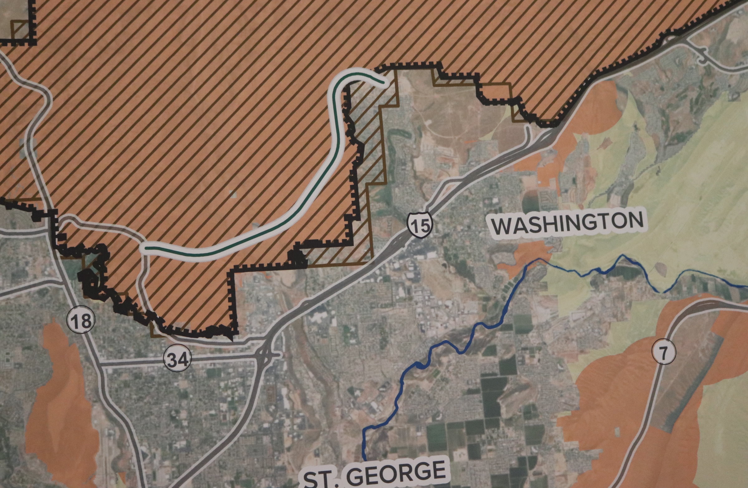
Various state and local officials are pleased with the results of the draft environmental impact statement – also commonly known as an EIS – as the preferred alternative for the project is the route proposed by the Utah Department of Transportation. This route cuts through the Red Cliffs Desert Reserve and overlaps the Red Cliffs Conservation Area.
“We are thrilled that the federally preferred alternative is the route that Washington County designed several years ago after seeking input from desert tortoise biologists and transportation planners,” Washington County Attorney Eric Clarke said in a press release Friday.
“The county and state have put forward a plan that (1) meets our area transportation needs, (2) benefits the desert tortoise recovery efforts, (3) and will not impose unrealistic social or financial burdens to area residents.”
Attached to the draft EIS is also an amended plan for the Washington County Habitat Conservation Plan which governs the management of the Red Cliffs Desert Reserve. A proposed version of the plan accounts for the creation of the Northern Corridor and the addition of nearly 6,900 acres in an area west of Bloomington in the Bear Claw Poppy Trail area that would be incorporated into the reserve.
The additional acreage, known as “Zone 6,” has been proposed as a way to help offset the impacts the Northern Corridor’s UDOT alignment is anticipated to create.
Adoption of the amended HCP will renew the plan for another 25 years. While the current plan expired in 2016, the Fish and Wildlife Service has allowed it to continue as it and other parties involved, such as Washington County and other federal and state agencies, addressed various issues attached to the renewal process.

The county estimates that 600 desert tortoises currently outside of the reserve will be brought into it if Zone 6 is created with the adoption of the UDOT alignment alternative.
According to Washington County, biologist and Red Cliffs Desert Reserve administrator Cameron Rognan estimates that just under 40 tortoises will need to be relocated due to the construction of the Northern Corridor.
“This is a win-win. Local leaders have been working hard for several years to craft the proposal that is now up for public comment,” Washington County Commissioner Dean Cox said, “Our proposal strikes a balance that will alleviate traffic congestion and allow population growth to continue, while protecting significantly more tortoises and land.”
The proposed highway, which would stretch four miles from a connection to Washington Parkway on its east end and connect to Red Hills Parkway on the western end, is seen as a crucial piece of transportation infrastructure by state and local officials. They have stated for years that the preexisting traffic system will “fail” if the Northern Corridor is not constructed in order to help relieve increased traffic that will come with a projected county population of nearly 500,000 by 2060.
Created in 1996, the Red Cliffs Desert Reserve was a compromise that allowed 62,000 acres in Washington County to be set aside for the protection of the threatened Mojave desert tortoise. The reserve’s creation allowed 300,000 acres to be opened up to future development instead of shut down due to the presence of the desert tortoise. Any tortoises found in developing areas outside of the reserve were subsequently relocated, which allowed development and growth within Washington County to continue.

In 2009, Congress passed the Omnibus Public Lands Act that created the Red Cliffs National Conservation Area, which overlaps approximately 75% of the desert reserve. It has been argued by Washington County officials that the Bureau of Land Management was supposed to designate a route for the Northern Corridor route soon after that legislation’s passing, yet failed to do so.
Because the road would cut through land set aside for the protection of the desert tortoise, federal wildlife and lands officials had been reluctant to approve it. They had rejected routes proposed by county road planners because they were not seen as being compatible with federal environmental protection policy. This ultimately led to members of Utah’s Republican congressional delegation introducing bills to Congress to force the issue, yet failed to gain traction after Democrats took control of the House of Representatives following the 2018 midterm election.
Despite years of repeated setbacks, the push for the Northern Corridor gained momentum with UDOT and Washington County’s recent application for a right-of-way for the roadway and the subsequent release of the draft EIS Friday.
Local and regional environmental advocacy groups like Conserve Southwest Utah have been fighting against the Northern Corridor as long as local officials have been fighting for it.
“Washington County’s application for the Northern Corridor Highway would severely damage Red Cliffs NCA and set a dangerous precedent for development on public lands throughout our state and the country,” Conserve Southwest Utah said in a statement Friday.
“The highway would travel behind Washington County’s beloved ‘Sugarloaf’ in Pioneer Park. It would fragment the popular T-bone Trail and impact one of the most conveniently-accessed trail systems in all of Red Cliffs: Pioneer Park, Pioneer Hills and Pioneer Rim. This is a popular area to hike, mountain bike and ride horses in Red Cliffs NCA,” the local environment advocacy group said.
Conserve Southwest Utah also stated the proposed highway would create increased noise, air pollution, litter on trails and “drastically change the experience of spending time on these precious public lands.”
While Conserve Southwest Utah stands against any proposed highway alignment that cuts through the desert reserve and conservation area, it is nonetheless pleased other alternatives are being proposed in the draft EIS that people have a chance to comment on.
“At this stage, we’re encouraged to see that this draft includes transportation alternatives that would not destroy scenic beauty and access to trails in the Red Cliffs National Conservation Area,” Sarah Thomas, Conserve Southwest Utah’s public land program manager said in a press release Friday.

“This is the first time in over 20 years that alternatives to building a highway through the Red Cliffs National Conservation Area are being seriously studied and, hopefully, this indicates a willingness by the Bureau of Land Management to support the St. George community in relieving traffic congestion without sacrificing our quality of life and damaging this special place,” Thomas said.
The draft EIS presents six options for the Northern Corridor project which includes the aforementioned UDOT alignment, which is the preferred option, as well as a “no action” alternative that leaves things as they are.
Of the remaining four alternatives, two still cut through the Red Cliffs Desert Reserve and NCA between Green Springs Drive in Washington City and Red Hills Parkway in St. George. The other two alternatives, which are located outside of the reserve, would turn Red Hills Parkway into an expressway with limited access to on-off ramps, or turn St. George Boulevard and 100 South into one-way streets.
“The range of alternatives, including the preferred alternative, are not final,” the Bureau of Land Management stated in a press release. “Substantive comments may influence the alternatives when released in the Final EIS.”
The BLM and USFWS anticipate a final EIS and decision on the Northern Corridor project to be completed in the fall of 2020.
How to comment
The public comment period for the Northern Corridor project Environmental Impact Statement and related items began Friday and will run through Sept. 10. Comments can be submitted through the methods featured below:
-
- Standard mail: Bureau of Land Management, Attn: Northern Corridor, 345 East Riverside Drive, St. George, UT 84790.
- Email: [email protected].
Copyright St. George News, SaintGeorgeUtah.com LLC, 2020, all rights reserved.