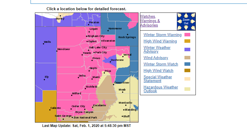
ST. GEORGE — The National Weather Service has issued a winter storm warning advising motorists of heavy snow expected in the mountains of central and Southern Utah and gusting winds from 10 p.m. Sunday to 4 a.m. Tuesday, as snow pack levels continue to rise across Dixie National Forest.
Affected areas
Central and Southern Utah mountains including Brighton, Mirror Lake Highway, Scofield, Cove Fort, Koosharem, Fish Lake, Loa, Panguitch and , Bryce Canyon. Starting Monday afternoon, Sanpete/Sevier Valleys, West-Central Utah, Southwest Utah, including the cities of Manti, Richfield, Delta, Fillmore, Beaver, Cedar City and Milford.
Snow Accumulations
Heavy snow expected — total accumulation of 4 to 8 inches and as much as 16 inches is expected along the I-15 corridor.
Wind advisory
Winds gusting as high as 55 mph are expected.

Timing
Snow will develop and become heavy at times into Sunday night and continue until early Tuesday morning.
Precautions
A winter storm warning for heavy snow means significant accumulations of snow are expected or are occurring and blowing snow will cause additional visibility reductions. The hazardous conditions will impact the morning and evening commutes on Monday.
Driving conditions may be hazardous. Use caution. Keep a winter storm survival kit in your vehicle in case of an emergency.
Prepare and take caution
Utah law requires vehicles to have either steel link or cable chains or snow tires when driving roads in winter conditions October through March. The Utah Department of Transportation’s infographic with particulars is included below.
Following are guidelines and supplies recommended for survival in the event you find yourself stuck somewhere in the snow or just out in the cold in your vehicle. These derive from tips given by the Washington County Sheriff’s Search and Rescue, the CDC- Outdoor Safety During a Winter Storm and the U.S. Search and Rescue Task Force.
Stay in your vehicle
- Disorientation occurs quickly in wind-driven snow and cold.
- Run the motor about ten minutes each hour for heat.
- Open the window a little for fresh air to avoid carbon monoxide poisoning.
- Make sure the exhaust pipe is not blocked.
- Make yourself visible to rescuers.
- Turn on the dome light at night when running engine.
- Tie a colored cloth (preferably red) to your antenna or door.
- Raise the hood indicating trouble after snow stops falling.
- Exercise from time to time, by vigorously moving arms, legs, fingers and toes to keep blood circulating and to keep warm.
- Wear a hat, half your body heat loss can be from the head
- Cover your mouth to protect your lungs from extreme cold.
- Mittens, snug at the wrist, are better than gloves.
- Loose-fitting, lightweight, warm clothing in several layers is best, trapped air insulates and layers can be removed to avoid perspiration and subsequent chills.
- Outer garments should be tightly woven, water repellent and hooded.
- Safely removing tires and upholstery from your vehicle and lighting them on fire in a cleared area will create smoke to facilitate your being located.
Additional tips
- Stay dry—wet clothing chills the body rapidly.
- Excess perspiration will increase heat loss, so remove extra layers of clothing whenever you feel too warm.
- Also, avoid getting gasoline or alcohol on your skin while de-icing and fueling your car or using a snow blower. These materials in contact with the skin greatly increase heat loss from the body.
- Do not ignore shivering. It’s an important first sign that the body is losing heat. Persistent shivering is a signal to return indoors.
Avoid frostbite and hypothermia
Hypothermia
Hypothermia is caused by prolonged exposure to very cold temperatures, when the body begins to lose heat more rapidly than it’s able to produce. Lengthy exposures will eventually use up the body’s stored energy, which leads to lower body temperature, and if it becomes too low it can affect the brain, making the victim unable to think clearly or move well. Consequently, a person may not know it’s happening and won’t be able to do anything about it before it’s too late, which makes it particularly dangerous.
Frostbite
Frostbite is a bodily injury caused by freezing that causes a loss of feeling and color in affected areas, including the nose, ears, cheeks, chin, fingers, or toes, and the condition can cause permanently damage to the body, and in severe cases can even lead to amputation.
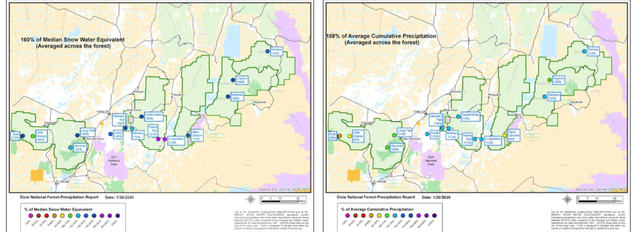
Dixie National Forest snow pack
The Snow Telemetry Network shows Dixie National Forest is at 160% of the 30 year Median Snow Pack (for water content), and 108% of the 30 year average precipitation for this time of year. The below maps that show values at each of the individual sites.
showing where the Dixie National Forest is for snow pack and precipitation so far this water year, which started on October 1.
The average across the Forest is at 160% of the 30 year Median Snow Pack (for water content), and 108% of the 30 year average precipitation for this time of year. The below maps that show values at each of the individual sites.
Copyright St. George News, SaintGeorgeUtah.com LLC, 2020, all rights reserved.