ST. GEORGE — The National Weather Service in Salt Lake City has issued a hazardous weather outlook Thursday for the western two-thirds of the state of Utah and southwest Wyoming, including Washington, Iron and Kane counties extending out to Lake Powell.
Day one – Saturday
Light snow will begin to develop across the northern mountains Saturday night
Days two through seven – Sunday through Friday
A potent Pacific storm system will impact the region during the latter half of the holiday weekend into early next week, bringing snow and much colder temperatures. Ahead of this storm south winds are expected to become gusty and potentially strong across western Utah Sunday.
The cold front will likely be accompanied by a band of heavy snow as it crosses northern Utah Sunday afternoon, then central and southwest Utah Sunday evening into Sunday night.
Heavy snow may linger through Monday and possibly into Tuesday across mountainous locations favored in northwest flow, as well as locations downwind of the Great Salt Lake and Utah lake. Snow is expected to taper off by Tuesday afternoon.
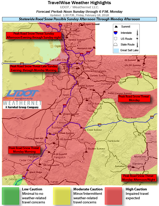
Driving conditions
The storm will drive a cold front and a band of moderate to heavy snow throughout the state.
Strong gusty winds of 30-55 mph and possibly more along and immediately behind the front will bring the concern for reduced visibility with blowing and drifting snow, especially over mountain summits and passes.
Periods of heavy road snow are expected to quickly develop behind this cold front for all routes. High caution for impaired travel is expected for much of the state.
Snow starts to decrease Monday evening/night but will not come to an end until Tuesday. All motorists are advised to use caution and travel wise, as numerous routes across the state will be significantly impacted by this storm. The following major routes are expected to have weather-related travel concerns during the forecast period:
- I-15, Entire Route
- I-215, Entire Belt Route
- I-80, Entire Route
- I-84, Entire Route
- I-70, Entire Route
- US-89, Entire Route
- US-40, Entire Route
- US-6, Entire Route
- US-191, Entire Route
- US-491, Entire Route
Spotter information statement
Weather spotters are encouraged to report significant weather conditions according to standard operating procedures.
Prepare and take caution
Motorists should stock vehicles with a number of items that can make the difference between death and survival in the event of getting stuck in the snow.
Read more: Stocking your vehicle for winter; what to do in case of emergency, checklist.
Download this printable PDF: Vehicle Preparation and Safety Precautions for Winter Weather. This is a project the whole family could participate in – make it a scavenger hunt with potentially lifesaving benefits.
Resources
- NOAA National Weather Service
- UDOT’s Road Weather Alerts
- UDOT’s Current Road Conditions
- UDOT’s smartphone travel app.
Email: [email protected]
Twitter: @STGnews
Copyright St. George News, SaintGeorgeUtah.com LLC, 2018, all rights reserved.