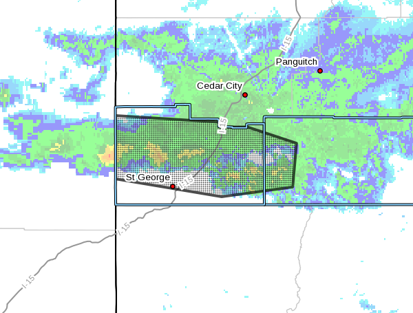
ST. GEORGE – The National Weather Service in Salt Lake City has issued a flood warning for all of Washington County and the west central section of Kane County, effective until 11:45 p.m. tonight.
At 5:37 p.m., Doppler radar and automated rain gauges indicated that heavy rain was falling over the area. This heavy rain will result in flooding. Flooding has been reported in Zion National Park. Rockfalls have also been reported on roadways in steep terrain.
Some of the locations expected to experience flooding include:
- Beaver Dam, St George, Washington, Hurricane, Santa Clara, La Verkin, New Harmony, Zion National Park, Ivins, Toquerville, Leeds, Virgin, Orderville, Springdale, Rockville, Pine Valley, Veyo, Gunlock, Snow Canyon State Park and Mt Carmel.
Precautionary – preparedness action
Flooding is occurring or is imminent. It is important to know where you are relative to streams, rivers or creeks which can become killers in heavy rains.
Campers and hikers should avoid streams or creeks.
Please report flooding to your local law enforcement agency when you can do so safely.
Turn around. Don’t drown.
The National Oceanic and Atmospheric Association and the National Weather Service offer safety rules for flash flooding:
- Flash flooding is a very dangerous situation
- Flash flood waves, moving at incredible speeds, can roll boulders, tear out trees, destroy buildings and bridges, and scour out new channels. Killing walls of water can reach heights of 10 to 20 feet. You will not always have warning that these deadly, sudden floods are coming. When a flash flood warning is issued for your area or the moment you first realize that a flash flood is imminent, act quickly to save yourself. You may have only seconds.
- Most flood deaths occur in automobiles. Do not drive your vehicle into areas where the water covers the roadway. Flood waters are usually deeper than they appear. The road bed may not be intact under the water. Just one foot of flowing water is powerful enough to sweep vehicles off the road. If the vehicle stalls, abandon it immediately and seek higher ground. Rapidly rising water may engulf the vehicle and its occupants and sweep them away
- Do not hike rivers and especially slot canyons while flash flood warnings are in place
- Do not hike alone and always tell someone where you and your buddy and others are going
- Get out of areas subject to flooding, including dips, low spots, canyons, and washes
- Avoid already flooded and high velocity flow areas. Do not try to cross a flowing stream on foot where water is above your knees
- Be especially cautious at night when it is harder to recognize flood dangers
- Do not camp or park your vehicle along streams and washes, particularly during threatening conditions
During any flood emergency, stay tuned to your NOAA weather radio, commercial radio, or television, follow St. George News at STGnews.com and St. George News Facebook for weather alerts and updates relevant to Southern Utah. Information from the national weather service and disaster and emergency services may save your life.
Read more: Rescue commander tells how to survive a flash flood
Email: [email protected]
Twitter: @STGnews