ST. GEORGE — A “Hazardous Weather Outlook” has been issued by the National Weather Service, Wednesday-Tuesday, for the western two-thirds of Utah and southwest Wyoming, including Southwest Utah, Utah’s Dixie, Zion National Park, south central Utah, Glen Canyon Recreation Area and Lake Powell.
Day one — Wednesday
Scattered snow showers will continue across northern Utah and southwest Wyoming Wednesday afternoon and night, with additional light accumulation possible.
Days two through seven — Thursday through Tuesday
Another storm system is expected to bring snow to much of the outlook area Christmas Eve into Christmas Day. Significant snow is possible over most of the outlook area, and travel will be impacted.
Avalanche advisory: Moab area mountains
Human-triggered avalanches are likely Wednesday, and the danger is “high” in upper elevation, wind-exposed terrain on slopes steeper than about 30 degrees that face NW-NE-SE. Below the treeline, the avalanche danger is “considerable.”
Avalanches may be triggered remotely and from adjacent, lower-angle slopes. Stay off and out from under steep terrain. Only experienced backcountry travelers with excellent route-finding skills and a high-level of avalanche awareness should travel in the mountains Wednesday.
For more detailed information from the Utah Avalanche Center, visit its website here.
Road conditions
Periods of snow continue across much of Utah, remaining heavy over northern mountain routes. Valley routes along the Wasatch Front southward to Cedar City will be susceptible to road slush. Then, heavier snowfall returns to northern Utah through Wednesday morning, with several inches of road snow from Utah Valley northward to the Idaho line.
This looks to impact the Wednesday morning commute along northern valley routes. Southern valley routes can expect some minor impacts as well, with slush or light road snow anticipated. Meanwhile, generally heavy snow continues through Wednesday across mountain routes, with concerns for blowing snow resuming as well. Improving conditions develop by late Wednesday.
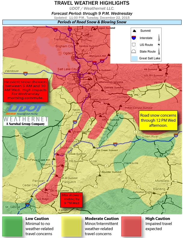
The following major roadways will be impacted by road slush or snow during the forecast period:
- I-15, Idaho border to near Cedar City
- I-70, I-15 Junction to San Rafael Swell; and near the Colorado border
- I-80, entire route
- I-84, entire route
- US-89, entire route
- US-191, Wyoming border to Helper; east of Price to north of Green River; south of Moab to Blanding
- US-189, Provo Canyon
- US-6, Spanish Fork Canyon over Soldier Summit to Helper
- US-40, entire route
Spotter information statement
Weather spotters are encouraged to report significant weather conditions according to standard operating procedures.
Email: [email protected]
Twitter: @STGnews
Copyright St. George News, SaintGeorgeUtah.com LLC, 2015, all rights reserved.
I-80, entire route (from California to New Jersey?)
US-89, entire route (from Arizona to Montana?)
When you are only talking about Utah, you should say so. And your “outlook area” should include nearby places in Arizona and Nevada that are important for people in our area. Thanks in advance.
Utah’s brush with El Nino ?
At least the storm didn’t drop Everything in the Sierras .
Thanks for leaving Some for Utah !
TRUMP FOR PRESIDENT !