Update 11/10 3:40 p.m. — The Winter Weather Advisory is now in effect until 5 a.m. Wednesday.
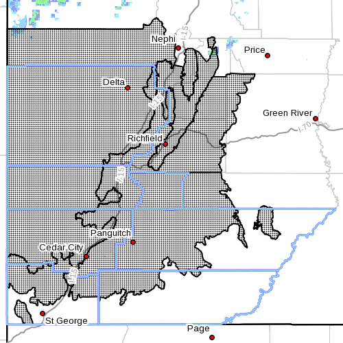
SOUTHERN UTAH — The National Weather Service in Salt Lake City has issued a Winter Weather Advisory for snow for Washington, Iron, Beaver, Kane and Garfield counties in effect from 8 p.m. Monday to 10 p.m. Tuesday.
The Weather Service also issued an advisory for snow and blowing snow above 5,000 feet, in effect from 8 a.m. to 10 p.m. Tuesday.
Affected areas
The Sanpete and Sevier valleys, west-central and southwest Utah, along with the central and southern mountains.
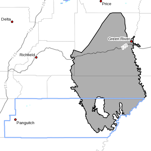
Above 5,000 feet: San Rafael Swell.
Snow accumulations
Two to 6 inches across the valleys, with 7-14 inches in the mountains.
Above 5,000 feet: One-4 inches.
Timing
Snow will spread in from west central Utah Monday night, reaching southwest Utah and the southern mountains Tuesday morning. The heaviest burst is expected midday Tuesday before gradually diminishing late Tuesday afternoon and evening.
Above 5,000 feet: Snow will spread into the area midmorning Tuesday, becoming heaviest Tuesday afternoon before diminishing Tuesday evening.
Winds
Above 5,000 feet: Northwest winds with gusts exceeding 35 mph are possible late Tuesday into Tuesday night.
Impacts
Winter driving conditions may develop, including the Interstate 15 corridor between Cedar City and Cove Fort, and along Interstate 70 between Salina and Fremont Junction.
Above 5,000 feet: Winter driving conditions may develop on area roadways including the higher elevations of I-70 between Fremont Junction and Green River.
Gusty northwest winds may combine with the fallen snow to cause areas of reduced visibility due to blowing and drifting snow late Tuesday and Tuesday night, especially along I-70 near Fremont Junction.
Precautionary, preparedness actions
A Winter Weather Advisory means that visibility will be limited due to a combination of falling and blowing snow. Use caution when traveling, especially in open areas. Be prepared for snow-covered roads.
Email: [email protected]
Twitter: @STGnews
Who picked out the above photo. Not only is it not Southern Utah but it not even in the U.S. Notice the drivers are on the wrong side of the road and the drivers are behind the steering wheel on the right side of the interior of the car. Great Britain maybe.
Well, 07ab – when you’re right, you’re right. We’ll call this a “one appearance only” featured image. We have enough accidents without people driving on the wrong side of the road, don’t we?!
Thanks for the morning laugh (at ourselves). Ridiculous.
ST. GEORGE NEWS
Joyce Kuzmanic
Editor in Chief
I don’t pay much attention to other drivers because I’m busy talking on my cell phone while driving