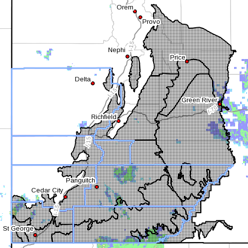
SOUTHERN UTAH — The National Weather Service in Salt Lake City has issued a flash flood watch for portions of central and southern Utah and an areal flood warning for a number of central and southern counties in Utah Monday and Tuesday
Flash flood watch
The service’s flash flood watch means that conditions may develop that lead to flash flooding.
The watch is in effect through 10 p.m. Tuesday, per updated notice at 2:48 p.m. Monday.
The watch is for Wasatch Plateau, Book Cliffs, Castle Country, the San Rafael Swell, Utah’s Dixie, Zion National Park, south-central Utah, the Lake Powell area, the central and southern mountains.
Widespread precipitation is expected to continue through Monday afternoon and evening across central and southern Utah. This long-duration rainfall will cause enhanced runoff across the area. Locally heavy rainfall will be possible in stronger thunderstorms.
Normally dry washes, small streams, slot canyons, areas near recent fires and streams in steep terrain will be most prone to flooding Tuesday, with many area streams and dry washes experiencing flows.
Affected areas
Cities in the watch area include Scofield, Price, Castle Dale, Emergy, Green River, Hanksville, St. George, Kanab, Escalante, Bullfrog, Cove Fort, Koosharem, Fish Lake, Loa, Panguitch and Bryce Canyon.
Precautionary/preparedness actions
Flash flooding is a very dangerous situation. You should monitor later forecasts and be prepared to take action should flash flood warnings be issued.
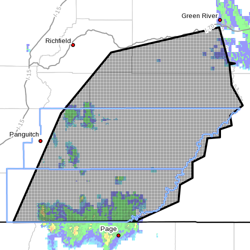
Areal flood warning
The service’s areal flood warning is for Wayne County, central San Juan County, Garfield and Kane counties, southeastern Piute county, southeastern Sevier county and southern Emery county, in effect until 10:30 p.m. Monday.
At 1:24 p.m., widespread rainfall throughout a large section of Southern Utah has produced slow river rises across the area. Slot canyons, dry washes and small rivers are anticipated to rise to dangerous levels through the afternoon hours.
Over an inch of precipitation has fallen over large portions of the area. Additionally, there are reports of rising small streams and flash flooding in Capitol Reef National Park.
Affected areas
Kanab, Escalante, Hanksville, Capitol Reef National Park, Loa, Big Water, Bickness, Henrieville, Boulder, Torrey, Hatch, Antimony, Bullfrog, Teasdale, Hite Marina, Bryce Canyon National Park, Ticaboo, Halls Crossing, Ordervill, Tropic
Precautionary/preparedness actions
Most flood deaths occur in automobiles. Never drive your vehicle into areas where the water covers the roadway. Flood waters are usually deeper than they appear. Just one foot of flowing water is powerful enough to sweep vehicles off the road.
When encountering flooded roads, make the smart choice: Turn around. Don’t drown.
UPDATED 3 p.m. per updated notice from the National Weather Service; watch time extended.
Related posts
- I can’t believe I survived; video of flash flood crashing down on canyoneers
- After the rain: Hundreds gather in remembrance of Hildale flood victims
- Utah mourns with Hildale: Gov. Herbert meets with flood victims’ families
Email: [email protected]
Twitter: @STGnews