SOUTHERN UTAH – Southern Utah residents made a rare sighting of a funnel cloud Monday afternoon twisting in the blue-gray sky over Kanab.
Kanab resident Bennett Brooks said he was at Garkane Energy Cooperation on Highway 89 around 1:30 p.m. when he saw the “huge” funnel cloud in the sky as he looked towards the southeast.
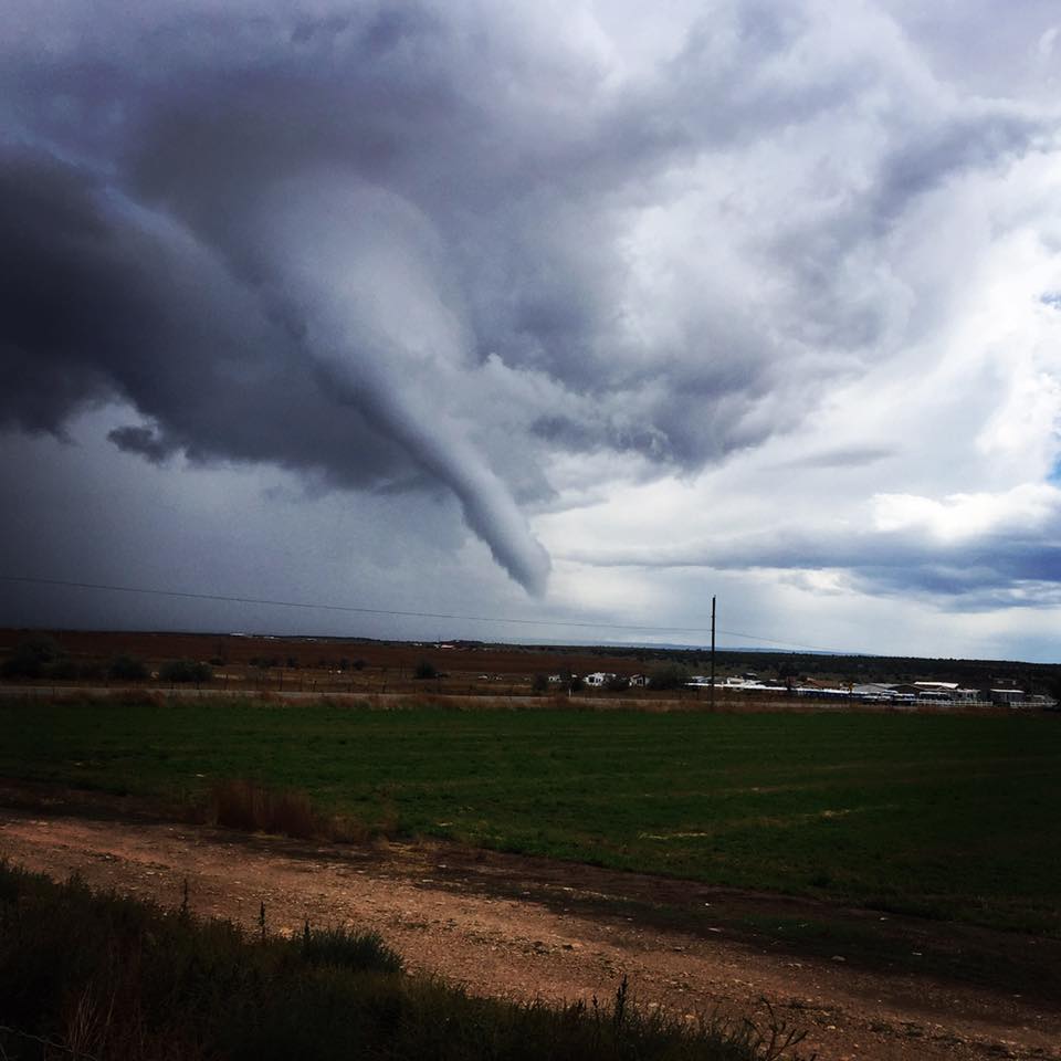
“It started out to be a small funnel cloud and then it grew into the tornado cloud that you see,” Brooks said. “It looked like it might touchdown (sic) but it was hard to tell.”
Brooks was able to snap several photos of the impressive cloud and said he believes he was probably a mile away from the cloud when the pictures were taken.
“It was neat to watch it go from tiny, you know, like the normal dust devils that we have in southern Utah,” he said, “to grow (into) that big tornado.”
While funnel clouds are not unheard of in Utah, Eric Shoening, a meteorologist with the National Weather Service in Salt Lake City, said they are fairly rare.
“Funnel clouds can occur anywhere if you get the right environment,” Schoening said during a May interview with St. George News, adding that they are usually not dangerous, and rarely touch the ground, although it can happen.
A funnel cloud becomes a tornado if it touches the ground, Schoening said. While funnel clouds are uncommon, he said, tornadoes are very rare in Utah.
An average of two tornado sightings occur each year in Utah, mostly in the warmer months between May and September. In 1998, there were eight confirmed tornados in Utah.
Click on photo to enlarge it, then use your left-right arrow keys to cycle through the gallery.

Rare funnel cloud sighted over Kanab, Utah, Oct. 5, 2015 | Photo courtesy of Bennett Brooks, St. George News

Rare funnel cloud sighted over Kanab, Utah, Oct. 5, 2015 | Photo courtesy of Bennett Brooks, St. George News

Rare funnel cloud sighted over Kanab, Utah, Oct. 5, 2015 | Photo courtesy of Bennett Brooks, St. George News

Rare funnel cloud sighted over Kanab, Utah, Oct. 5, 2015 | Photo courtesy of Bennett Brooks, St. George News

Rare funnel cloud sighted over Kanab, Utah, Oct. 5, 2015 | Photo courtesy of Bennett Brooks, St. George News

Rare funnel cloud sighted over Kanab, Utah, Oct. 5, 2015 | Photo courtesy of Bennett Brooks, St. George News

Rare funnel cloud sighted over Kanab, Utah, Oct. 5, 2015 | Photo courtesy of Teresa Hatch Kabonic, St. George News

Rare funnel cloud sighted over Kanab, Utah, Oct. 5, 2015 | Photo courtesy of Kasey Ferguson, St. George News

Rare funnel cloud sighted over Kanab, Utah, Oct. 5, 2015 | Photo courtesy of Kasey Ferguson, St. George News

Rare funnel cloud sighted over Kanab, Utah, Oct. 5, 2015 | Photo courtesy of Kasey Ferguson, St. George News
Related posts
- Rare funnel cloud spotted in Southern Utah
- Storms bring spectactular sights: sun halos, sundogs
- People from Iron, Washington counties attend storm spotter training; STGnews Videocast
Email: [email protected]
Twitter: @STGnews
Copyright St. George News, SaintGeorgeUtah.com LLC, 2015, all rights reserved.
being from central florida and having lived in mhp there when i was younger… i can honestly say, i know a little bit about storms and cloud base with tornados and i’m going to have to say, that is a really interesting feeder at the top/base of that tornado.. its more interesting than the actual tornado.. pretty cool pictures. i snapped a picture over hurricane from uphill (hwy.59) ( a panarama) about 12 of them one day all twelve pictures has a fairly large tornado hovering over hurricane and i didn’t even see it in the pictures for ages UNTIL i finally downloaded it to a desk computer one day.. i was like WOW how did i not see that! i looked the date up and no one in hurricane even noticed.. crazy. i think there are lots more tornados here than they even pick up on.. i always see circular patterns, two varied storms always converge over our area… i.e. from south and west..
Cool pics!