SOUTHERN UTAH — The National Weather Service has issued a “Flash Flood Watch” for central, south central and southwest Utah, in effect Sunday from 8 a.m. through midnight Monday.
Conditions
Numerous slow-moving showers and thunderstorms will track north across southern and central Utah. Some of these showers and thunderstorms will generate very heavy rain in short periods of time. Flash flooding will be possible in the more flash flood prone areas.
Flash flood in Washington County Saturday: Swiftwater, high angle teams rescue 13 campers stranded by 1:30 a.m. flash flood in slot canyon
Timing
The threat will shift north into central Utah into the afternoon and early evening.
Affected areas
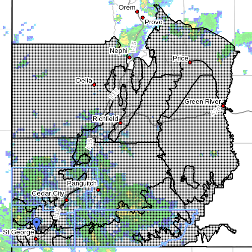
The affected areas include: Wasatch Plateau-Book Cliffs; Castle country; San Rafael Swell; Sanpete-Sevier valleys, west central Utah; southwest Utah; Utah’s Dixie and Zion National Park; south central Utah; Glen Canyon Recreation Area; Lake Powell; Central Mountains; southern mountains.
These areas include the following cities: Scofield, Price, Castle Dale, Emery, Green River, Hanksville, Manti, Richfield, Beaver, Cedar City, Milford, St. George, Kanab, Escalante, Bullfrog, Cove Fort, Koosharem, Fish Lake, Loa, Panguitch and Bryce Canyon.
Most threatened
The “Flash Flood Threat” will be greatest in slot canyons and slick rock areas. Areas of steep terrain or old burn scars will also be susceptible to flash flooding and or debris flow.
Precautionary/ preparedness action
A “Flash Flood Watch” means that conditions may develop that lead to flash flooding. Flash flooding is a dangerous situation. You should monitor later forecasts and be prepared to take action.
Turn around. Don’t drown.
The National Oceanic and Atmospheric Association and the National Weather Service offer safety rules for flash flooding:
- Flash flooding is a very dangerous situation
- Flash flood waves, moving at incredible speeds, can roll boulders, tear out trees, destroy buildings and bridges, and scour out new channels. Killing walls of water can reach heights of 10 to 20 feet. You will not always have warning that these deadly, sudden floods are coming. When a flash flood warning is issued for your area or the moment you first realize that a flash flood is imminent, act quickly to save yourself. You may have only seconds.
- Most flood deaths occur in automobiles. Do not drive your vehicle into areas where the water covers the roadway. Flood waters are usually deeper than they appear. The road bed may not be intact under the water. Just one foot of flowing water is powerful enough to sweep vehicles off the road. If the vehicle stalls, abandon it immediately and seek higher ground. Rapidly rising water may engulf the vehicle and its occupants and sweep them away
- Do not hike rivers and especially slot canyons while flash flood warnings are in place
- Do not hike alone and always tell someone where you and your buddy and others are going
- Get out of areas subject to flooding, including dips, low spots, canyons, and washes
- Avoid already flooded and high velocity flow areas. Do not try to cross a flowing stream on foot where water is above your knees
- Be especially cautious at night when it is harder to recognize flood dangers
- Do not camp or park your vehicle along streams and washes, particularly during threatening conditions
- During any flood emergency, stay tuned to your NOAA weather radio, commercial radio, or television, follow St. George News at STGnews.com and St. George News Facebook for weather alerts and updates relevant to Southern Utah. Information from the national weather service and disaster and emergency services may save your life
Related posts
- Rescue commander tells how to survive a flash flood
- Swiftwater, high angle teams rescue 13 campers stranded by 1:30 a.m. flash flood in slot canyon
- What to do before, during, after a flash flood
Email: [email protected]
Twitter: @STGnews
Copyright St. George News, SaintGeorgeUtah.com LLC, 2014, all rights reserved.
On that map you might as well draw a circle around Virgin for no rain. We haven’t had anything of significance the past months at all. Wow, the flash flood rains have generated about 1/4″ so far, oooooo……not.