SOUTHERN UTAH — The National Weather Service in Salt Lake City has upgraded its winter weather advisory Friday for five Southern Utah counties, issuing a winter storm warning for heavy snow, in effect until 8 p.m. Saturday.
The weather service has forecast “widespread snow to return” Friday night through Saturday.
“The next winter storm to impact Utah will move east from California and take aim on Southern Utah early Friday evening,” according to the warning. “Snow will expand north and east overnight, affecting all but the lowest elevations near the Arizona border through Saturday morning.”
Snow is expected to gradually taper off first in the valleys Saturday afternoon, then end in most remaining areas Saturday evening.

Affected area
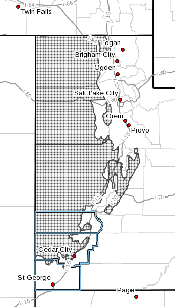
Southern mountains of Washington, Kane, Garfield, Beaver and Iron counties, including the cities of Loa, Panguitch and Bryce Canyon.
Snow accumulations
Eight to 18 inches with locally greater amounts.
Timing
Snow will increase in intensity and areal coverage early Friday evening, then remain heavy at times through Saturday morning. Snow will gradually taper off Saturday afternoon, then end most areas by late Saturday evening.
Winds
Gusty southerly winds at 25 to 35 mph Friday evening will switch to the west and decrease late Friday night.
Impacts
Winter weather conditions will exist on all mountain roads within the Southern Utah mountains. Significant travel impacts are anticipated along all routes across the southern mountains during this storm cycle.
Precautionary and preparedness actions
A winter storm warning for heavy snow means that significant accumulations of snow are expected or occurring. Driving conditions may be hazardous. Use caution. Keep a winter storm survival kit in your vehicle in case of an emergency.
Winter weather advisory in effect until noon Saturday
In addition to the winter storm warning, the National Weather Service in Salt Lake City has issued a winter weather advisory for snow for much of the state, including the Southern Utah counties of Washington, Kane, Garfield, Beaver and Iron.
Affected area
Sevier and Sanpete valleys and the Great Salt Lake Desert and mountains, west-central and southwest Utah, including the cities of Cedar City, Fillmore, Beaver, Milford, Wendover, Snowville, Manti, Richfield and Delta.
Snow accumulations
Generally, 1 to 3 inches with locally greater amounts along the Interstate 15 corridor through west-central and southwest Utah.
Timing
Snow will begin across southwest Utah by early Friday evening, then expand north across the entire advisory area by around midnight. Snow, heavy at times, will continue late Friday night through Saturday morning. Lingering snow showers Saturday afternoon will produce little additional accumulation.
Winds
Gusty, southerly winds at the onset of snow will diminish as snow intensities increase overnight.
Impacts
Significant travel impacts are anticipated along the major transportation corridors, including I-15 and I-80 along with highways 6, 50 and 89. The greatest impacts will be along I-15 from the I-70 junction south to the Cedar City area.
Precautionary and preparedness actions
A winter weather advisory for snow means that snow accumulations will cause primarily travel difficulties. Be prepared for snow covered roads. Use caution while driving.
Vehicle preparation and safety precautions for winter weather
Stay in your vehicle
- Disorientation occurs quickly in wind-driven snow and cold.
- Run the motor about 10 minutes each hour for heat.
- Open the window a little for fresh air to avoid carbon monoxide poisoning.
- Make sure the exhaust pipe is not blocked.
- Make yourself visible to rescuers.
- Turn on the dome light at night when running engine.
- Tie a colored cloth (preferably red) to your antenna or door.
- Raise the hood indicating trouble after snow stops falling.
- Exercise from time to time, by vigorously moving arms, legs, fingers and toes to keep blood circulating and to keep warm.
- Wear a hat; half your body heat loss can be from the head.
- Cover your mouth to protect your lungs from extreme cold.
- Mittens, snug at the wrist, are better than gloves.
- Loose-fitting, lightweight, warm clothing in several layers is best. Trapped air insulates, and layers can be removed to avoid perspiration and subsequent chills.
- Outer garments should be tightly woven, water repellent and hooded.
- Safely removing tires and upholstery from your vehicle and lighting them on fire in a cleared area will create smoke to facilitate your being located.
Supplies recommended to keep in your vehicle in case of emergencies
- Cellphone, portable charger and extra batteries.
- Windshield scraper.
- Battery-powered radio, extra batteries.
- Flashlights, extra batteries.
- Snack food.
- Extra hats, coats, mittens, change of clothes.
- Blankets.
- Chains or rope.
- Tire chains.
- Spare gas.
- Canned compressed air with sealant (emergency tire repair).
- Road salt and sand.
- Booster / jumper cables.
- Emergency flares.
- Bright colored flag; help signs.
- Lighter / matches (waterproof matches and a can to melt snow for water).
- First aid kit – (Basic first aid courses are recommended).
- Spare water.
- Hi-lift jack.
- Spare tire with keys for locking lug nuts.
- Spare keys.
- Shovel.
- Tow strap.
- Tool kit.
- Duct tape.
- Trash bags.
- Road maps.
- Compass.
- Towels, paper towels.
The above recommendations were compiled in 2015 from the Washington County Sheriff’s Search and Rescue website, the Center for Disease Control’s emergency winter weather checklist, the U.S. Search and Rescue Task Force’s website on blizzard preparedness. This is a list of suggestions, in no particular order of priority, and should not be presumed exhaustive.
Printable / savable pdf: Vehicle Preparation and Safety Precautions for Winter Weather.
Resources
Email: [email protected]
Twitter: @STGnews
Copyright St. George News, SaintGeorgeUtah.com LLC, 2017, all rights reserved.